BEST WESTERN PREMIER Bayerischer Hof Miesbach
12 Number of reviews:
100 % Recommendation rate:
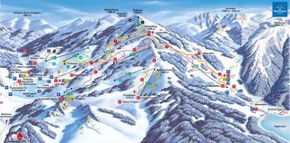
| Highest point: | 1,580 m |
| Lowest point: | 980 m |
| Altitude ski resort: | 700 m |
| Lifts in total: | 11 |
| Gondola lift: | 0 |
| Chair lifts: | 3 |
| Tow lifts: | 8 |
| Pistes in total: | 14.7 km |
|
Pistes:
|
2.2 km |
|
Pistes:
|
8.2 km |
|
Pistes:
|
4.3 km |
Weather & Snow report Miesbach
Snow levels & piste info last update: n/a
| Snow depth valley: n/a | Ski lifts open: n/a |
| Snow depth mountain: n/a | Pistes open (in km): n/a |
| Last snow fall: n/a | Toboggan run open: n/a |
| Snow condition: n/a | Snow park open: n/a |
| Winter hiking trails: n/a | Valley run open: n/a |
Snow report
Weather forecast
|
Today
28/04/25 |
Tomorrow
29/04/25 |
We
30/04/25 |
Th
01/05/25 |
|
|---|---|---|---|---|
| 5 days forecast | ||||
| Min. / max. temp. | 6 / 12 °C | 7 / 13 °C | 7 / 13 °C | 7 / 14 °C |
| Hours of sunshine | 11 h | 10 h | 12 h | 12 h |
| Fresh snow | 0 cm | 0 cm | 0 cm | 0 cm |
| Snowfall line | 2,500 m | 2,400 m | 2,400 m | 2,800 m |
|
Morning |
Midday |
Evening |
Night |
|
|---|---|---|---|---|
| Temperature | 7 °C | 10 °C | 9 °C | 7 °C |
| Wind speed | 5 km/h | 10 km/h | 10 km/h | 5 km/h |
| Fresh snow | 0 cm | 0 cm | 0 cm | 0 cm |
| Snowfall line | 2,500 m | 2,400 m | 2,600 m | 2,700 m |
|
Morning |
Midday |
Evening |
Night |
|
|---|---|---|---|---|
| Temperature | 8 °C | 11 °C | 9 °C | 8 °C |
| Wind speed | 5 km/h | 10 km/h | 15 km/h | 15 km/h |
| Fresh snow | 0 cm | 0 cm | 0 cm | 0 cm |
| Snowfall line | 2,600 m | 2,400 m | 2,400 m | 2,600 m |
|
Morning |
Midday |
Evening |
Night |
|
|---|---|---|---|---|
| Temperature | 8 °C | 12 °C | 10 °C | 8 °C |
| Wind speed | 10 km/h | 15 km/h | 10 km/h | 5 km/h |
| Fresh snow | 0 cm | 0 cm | 0 cm | 0 cm |
| Snowfall line | 2,600 m | 2,500 m | 2,700 m | 2,700 m |
|
Morning |
Midday |
Evening |
Night |
|
|---|---|---|---|---|
| Temperature | 9 °C | 12 °C | 11 °C | 10 °C |
| Wind speed | 5 km/h | 10 km/h | 5 km/h | 15 km/h |
| Fresh snow | 0 cm | 0 cm | 0 cm | 0 cm |
| Snowfall line | 2,600 m | 2,800 m | 2,800 m | 2,800 m |
|
Today
28/04/25 |
Tomorrow
29/04/25 |
We
30/04/25 |
Th
01/05/25 |
|
|---|---|---|---|---|
| 5 days forecast | ||||
| Min. / max. temp. | 6 / 21 °C | 7 / 22 °C | 7 / 23 °C | 8 / 25 °C |
| Hours of sunshine | 11 h | 11 h | 13 h | 12 h |
| Fresh snow | 0 cm | 0 cm | 0 cm | 0 cm |
| Snowfall line | 2,600 m | 2,500 m | 2,400 m | 2,800 m |
|
Morning |
Midday |
Evening |
Night |
|
|---|---|---|---|---|
| Temperature | 7 °C | 19 °C | 17 °C | 9 °C |
| Wind speed | 0 km/h | 10 km/h | 0 km/h | 0 km/h |
| Fresh snow | 0 cm | 0 cm | 0 cm | 0 cm |
| Snowfall line | 2,500 m | 2,400 m | 2,600 m | 2,700 m |
|
Morning |
Midday |
Evening |
Night |
|
|---|---|---|---|---|
| Temperature | 8 °C | 20 °C | 18 °C | 10 °C |
| Wind speed | 0 km/h | 10 km/h | 5 km/h | 5 km/h |
| Fresh snow | 0 cm | 0 cm | 0 cm | 0 cm |
| Snowfall line | 2,600 m | 2,400 m | 2,400 m | 2,600 m |
|
Morning |
Midday |
Evening |
Night |
|
|---|---|---|---|---|
| Temperature | 9 °C | 20 °C | 20 °C | 11 °C |
| Wind speed | 0 km/h | 10 km/h | 5 km/h | 0 km/h |
| Fresh snow | 0 cm | 0 cm | 0 cm | 0 cm |
| Snowfall line | 2,600 m | 2,400 m | 2,700 m | 2,700 m |
|
Morning |
Midday |
Evening |
Night |
|
|---|---|---|---|---|
| Temperature | 10 °C | 23 °C | 21 °C | 12 °C |
| Wind speed | 0 km/h | 10 km/h | 5 km/h | 5 km/h |
| Fresh snow | 0 cm | 0 cm | 0 cm | 0 cm |
| Snowfall line | 2,600 m | 2,800 m | 2,800 m | 2,800 m |
Climate
- Hours of sunshine
- Snow fall (cm)
- Snow days
| 2024 | 2025 | ||||||||||
|---|---|---|---|---|---|---|---|---|---|---|---|
| Apr | May | Jun | Jul | Aug | Sep | Oct | Nov | Dec | Jan | Feb | Mar |
| 5 h | 5 h | 6 h | 7 h | 8 h | 6 h | 5 h | 5 h | 4 h | 4 h | 5 h | 6 h |
| 73 | 2 | 0 | 0 | 0 | 86 | 24 | 53 | 76 | 52 | 26 | 69 |
| 13 | 1 | 0 | 0 | 0 | 7 | 2 | 7 | 13 | 9 | 6 | 12 |
Weather data source:© GeoSphere Austria
Snow data source: Skiresort


